It plans the passage. You still decide.
RoutingPlotting a passage by hand is the part of trip planning that everybody says they enjoy and almost nobody does properly. It takes twenty minutes, it needs the chart open, and the honest version of what most people do is draw a line and hope the bit in the middle is deep enough.
Tell it where you are going
Give theONE a start and a finish and it will lay out a route between them — a real chain of waypoints that stays in navigable water, keeps clear of what should be kept clear of, and holds to the depth your boat needs rather than a generic one.
Including the long ones
This is the part we are quietly proud of. Auto-routing on the water is a hard problem at any distance, and it gets dramatically harder the further you go — which is why the marine apps that offer it at all tend to offer it for a harbour hop and quietly decline the passage you actually wanted planned.
The reliable band is the coastal passage: legs up to about a hundred miles, back in twenty to a hundred seconds, ending on your pin. That is where most of a season’s planning actually happens.
Not a harbour entrance. Not the last two miles into a marina. Cameron to Galveston is 79 nm point to point and comes back as a 107 nm route over 82 waypoints, with 77% of the passage inside maintained channel — the extra miles are the router staying in dredged water rather than cutting the corner. Naples to Key West is 94 nm of open water and finishes on the destination in 97.
Beyond that it keeps going — well past the coastal band, up to a limit of its own — and it gets honest about the cost. We used to print two named long runs here, with their times and their waypoint counts. Neither reproduces on the build you would be buying, so the numbers came down rather than stand as a claim nobody can repeat.
So: minutes, not seconds, and on the longest passages sometimes a first draft that gets you most of the way rather than all of it. We would rather print that here than let you find it at the chart table. Two things follow from it. The app tells you on the screen exactly how far short it stopped, in nautical miles, instead of drawing a line to your pin it cannot justify. And on the densest stretches of coast a leg can hold more charted detail than the router can take in one go, in which case it says so and asks you to drop one waypoint in the middle and take it as two legs — which is a real limit on a real coastline, and two auto-routed halves is still an evening you get back.
Where it stops working, it stops cleanly. A route it cannot finish comes back as a partial or is declined, and either way the app says why, with the reason in feet and nautical miles.
Getting this far took a long time and a genuinely different approach, and we are not going to explain how it works. What matters to a captain is what comes out the other end, and what comes out is a route you can look at, understand, and disagree with.
On the chart, with the numbers that matter
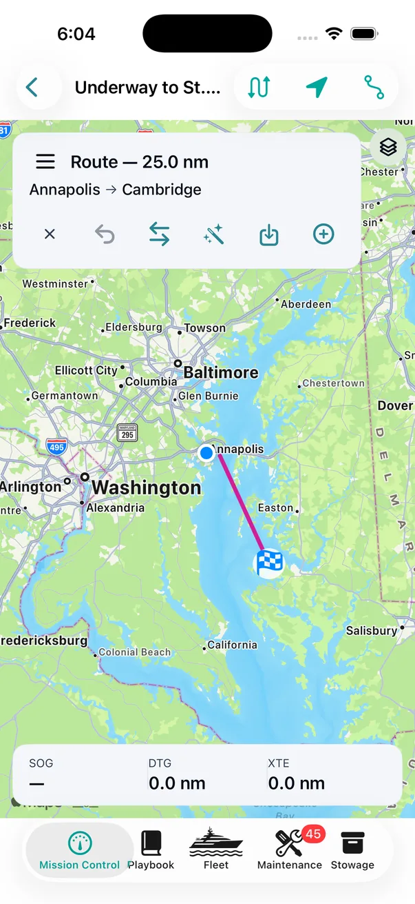
However the route was made, it lives on the chart with the leg, and under way it carries the three numbers you actually steer by.
It will not guess your draft
Ask it to route before the boat's draft is on file and it stops and asks for it, in one small card, and then carries straight on. It does not assume, and it does not fall back to something typical for the size.
A wrong guess could mark a six-foot sounding “safe” for a nine-foot keel. There is no version of that we are willing to ship.
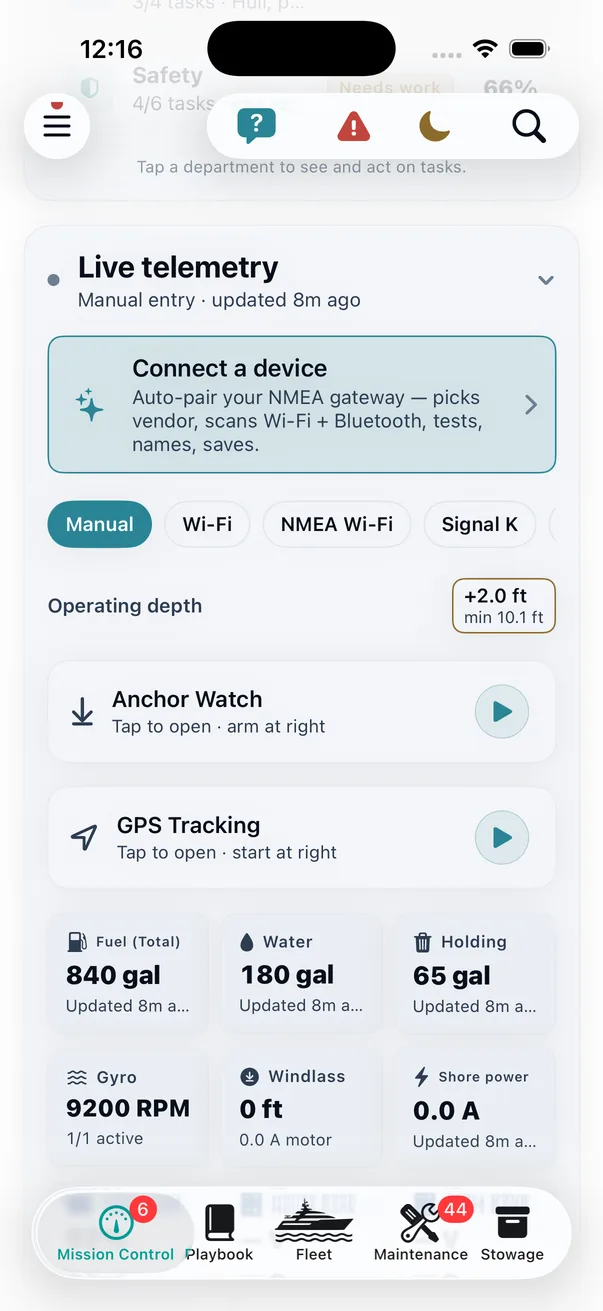
From the draft it works out the boat’s minimum operating depth — your draft plus a safety margin — and that is the figure the router holds to in open water. It sits on the chip before you ask for a route — not quoted back at you afterwards as the reason one was refused.
There is one place it relaxes, and only one. Inside a charted maintained channel — a dredged federal cut, surveyed and kept to a depth — the router drops the added margin. The margin exists to cover bottom nobody has measured recently, and in a maintained channel somebody has. It can only ever relax there, never tighten, and outside the channel the full figure is back the moment the route leaves it.
The depth on the chip is the depth the planner requires. One boat, one number.
Set your own minimum instead and yours wins, because it is your boat and your bottom. Some captains want more on an unfamiliar lee shore at night; some want less at slack water in a creek they have run for twenty years. What theONE will not do is let the two figures disagree behind your back.
The per-leg under-keel margin is a second, separate knob doing a separate job: it is what the app checks soundings against when you plot a leg by hand and want the pins that are too shallow for you flagged red. Presets for the three answers most captains actually give (conservative, default, and skinny water for when you know exactly what you are doing), or step it yourself half a foot at a time. Both are adjustable before you leave and while you are running — the same chip is on Mission Control under way.
You review it before it exists
A proposed route is not a committed route. theONE shows you the proposal on the chart with your own straight-line plot underneath it in faint red — the passage you would have drawn without it — because the difference between the two lines is the whole point and you should be the one who judges whether it was worth it.
With it comes the arithmetic in one line, a plain-language list of what it kept you away from, and three buttons: accept it, accept it and keep editing, or reject it and keep what you had. Every waypoint stays draggable afterwards. It is a first draft written by something that has read the chart, not an instruction.
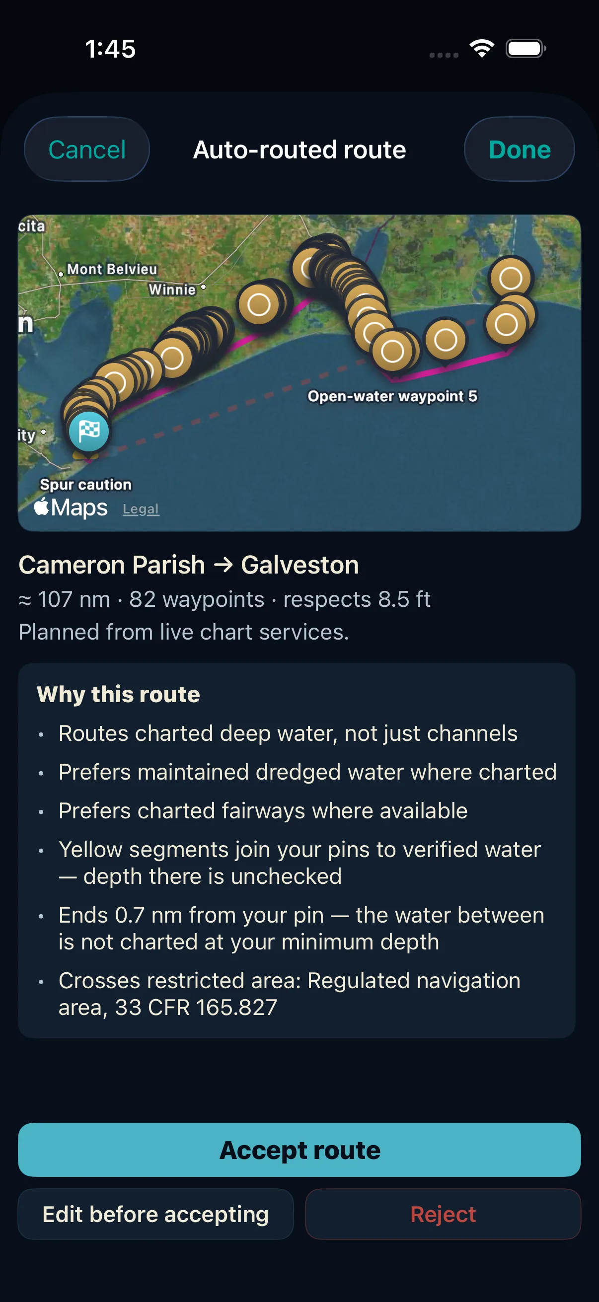
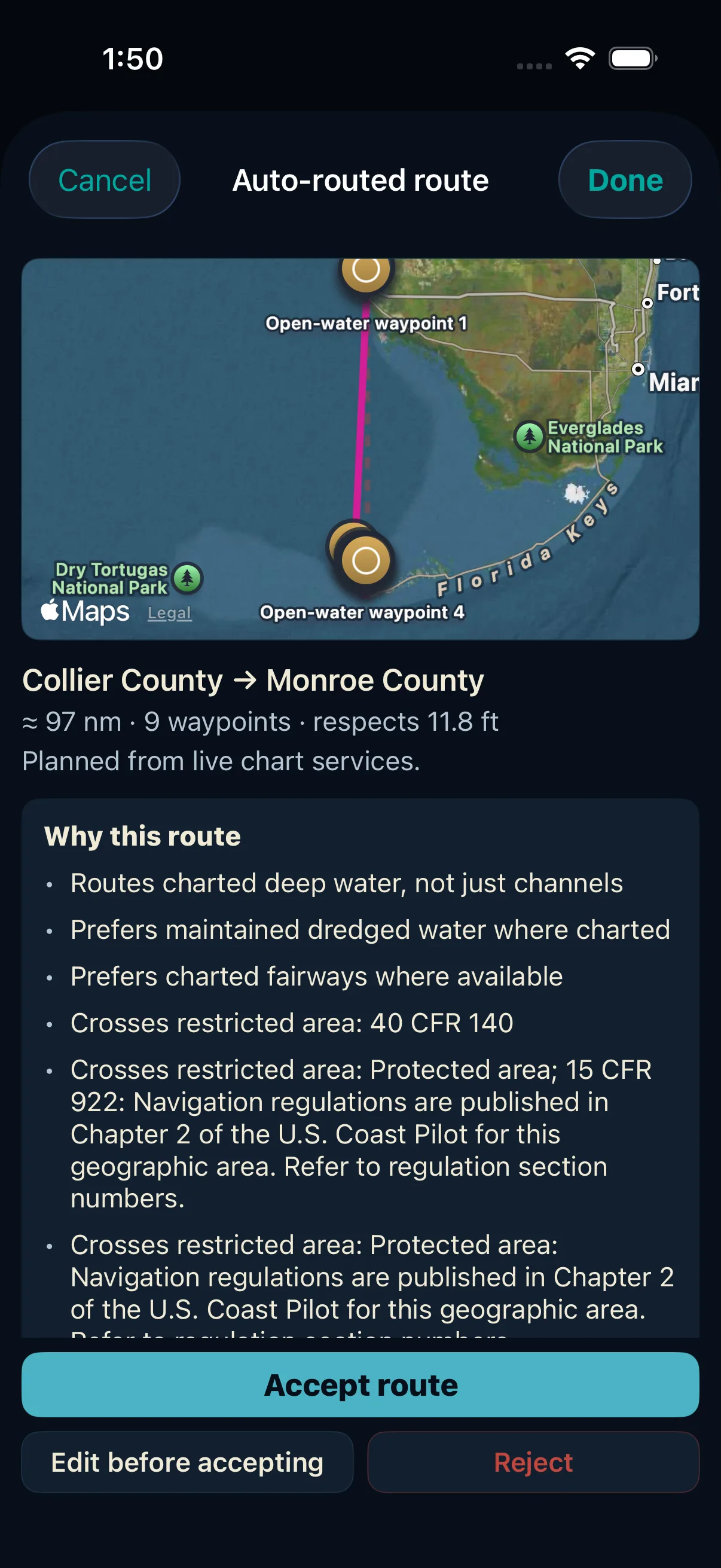
Look at what the Why this route block is doing there. It is not a progress log and it is not a disclaimer — it is the route arguing its own case, in the order a captain would ask: what water did you use, what did you prefer, what did you cross, and where are you least sure. The yellow-segment line is the one to notice: the app tells you which parts of its own answer it has not verified, before you accept it, rather than after something goes wrong.
And when it can’t
Sometimes there is no route to give you. The margin is tighter than the water, the passage is closed, or the chart data will not come down. theONE says so.
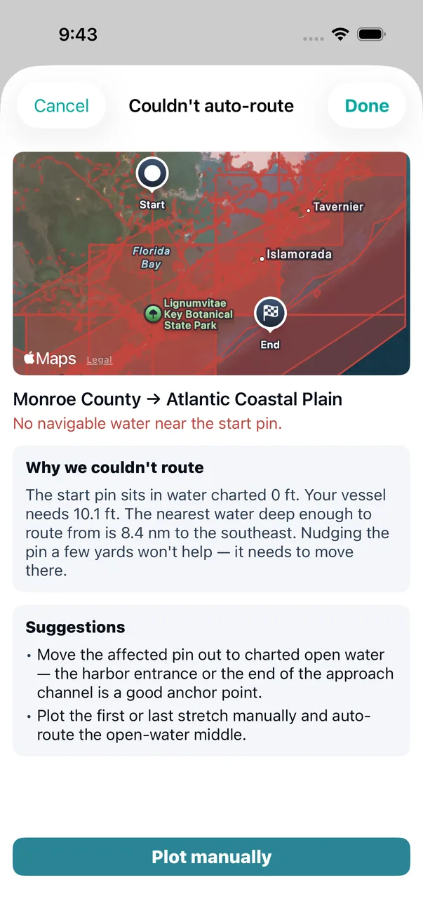
It does not hand you a route that ignores the constraint you set and leave you to notice. The screen turns from teal to red, it tells you what stopped it, and it draws what it was looking at — the restricted areas, the shallow ground — so you can see the problem rather than take its word for it.
Look at what it says on a leg that is too dense to route in one go. Not “routing failed” — it says the leg holds more charted detail than the router can take in one go, and that this is not a connection problem. Then it tells you not to bother retrying, which is the opposite of what software normally does with a failure it does not want to explain.
Where the problem is the pin rather than the leg, it is the same habit with different arithmetic. For the start pin in the screen above the app says: The start pin sits in water charted 0 ft. Your vessel needs 10.1 ft. The nearest water deep enough to route from is 8.4 nm to the southeast. Nudging the pin a few yards won’t help — it needs to move there. Three numbers: what the chart says is under the pin, what your boat needs by your own settings, and how far the usable water is and in which direction. That sentence exists because of a Miami Shores → North Bimini leg that was refused with its start pin in the shallows of north Biscayne Bay, and the old screen said only that there was no navigable water near the pin — not the depth under it, the depth needed, or where the usable water was. And when the chart has nothing to say about that spot it says that instead — no NOAA depth area covers the pin, so nothing there can be proven deep enough. An absence is reported as an absence and never as a zero.
Then it offers the ways forward that actually apply — in writing, as suggestions you read and judge for yourself. Where a pin sits in unnavigable water it says so. Where the chart service could not be reached it says that instead, because those are different problems and only one of them is yours to fix. What it will not do is put a button in front of you that promises a different answer from the same question. Plotting it yourself by hand is always available, in every case, and always will be.
We are not going to tell you it always finds a route. It does not, and any marine app that claims otherwise is either lying or has not been taken anywhere interesting. What we will tell you is that it never invents one.
Then it goes to the plotter
However the route was made — auto-routed, hand-plotted, or auto-routed and then argued with — it leaves as a GPX file, the universal chartplotter format. Garmin, Simrad, Lowrance, B&G, Raymarine, Furuno, by card or companion app. No proprietary format, no subscription, no re-typing waypoints at the helm with the engines running.
In the Help Center
Honest about the edges
Coverage is US coastal waters. Routing draws on NOAA chart data. Outside that coverage there is no auto-routing, and the app will tell you rather than improvise.
Route planning usually needs a connection. Not always. Download a chart region and its routing data is banked on the device as well — and where that covers your corridor, the planner works from what is already aboard. Outside it, building a proposal pulls current chart data. Either way, once a route is saved it is yours on the device, and everything under way works with no signal at all.
A proposal is a planning aid and nothing more. It is not a substitute for your own charts, your own local knowledge, or proper passage planning — and it cannot see a crab pot, a dragged buoy, or the shoal that moved last winter. Every waypoint is reviewable before you accept it, and that review is not a formality.
Charted depth is not the water you have. Soundings are a datum, not a promise. Tide, wind and season all move the real number, which is exactly why the margin is yours to set rather than ours to assume.
Why it is built to be argued with
Because a route is the one output of this app that gets steered. Everything else is a record somebody reads later; this becomes a line on a plotter with a boat following it at fifteen knots in the dark. Software that hands you that with confidence and no explanation has misunderstood the job. The best thing it can do is a good first draft, the reasoning behind it, and an honest answer when there is not one.